Overview
About eCognition Suite
Trimble® eCognition® Suite is an advanced analysis software available for geospatial applications. It is designed to improve, accelerate and automate the interpretation of a variety of geospatial data and enables users to design feature extraction or change detection solutions to transform geospatial data into geo-information.
eCognition imports a variety of geospatial data, fusing them together into a rich stack of geo-data for the analysis. The analysis logic is structured into series of steps to create a computer-based representation of an expert’s geospatial interpretation process a so called Rule Set. eCognition then combines the analysis logic with scalable computing power to identify changes over time or features on the earth’s surface across very large sets of data.
This eCognition Suite 10.4 is a major release and includes a range of new features and bug fixes. We recommend upgrading to this new version to benefit from the new features and improvements. For an overview of the highlights and a complete list of new features and bug fixes please refer to the following chapters.
Key Features
Building Analysis Solutions
The eCognition technology examines image pixels not in isolation, but in context. It builds up a picture iteratively, recognizing groups of pixels as objects. Just like the human mind, it uses color, shape, texture, shape and size of objects, as well as their context and relationships, to draw the same conclusions that an experienced analyst would draw.
To build an analysis solution, it is possible to flexibly combine the image interpretation steps like object creation (segmentation), object classification (knowledge based, fuzzy logic, machine learning), object detection (template matching) and object modification (fusing, smoothing, orthogonalization, simplification) into a Rule Set or even a new application (Rule Set with UI) to solve the analysis problem.
The result is a unique approach to translate mind models (why a human interpreter can see the objects, changes, or features in the geospatial data) into computer understandable code (Rule Set) or an individual/customized application.
Leveraging Data Synergies
eCognition can fuse a variety of geospatial data, such as spectral image data, 3D structure data from point clouds and spatial/thematic data from GIS vectors.
The proximity of eCognition to GIS, its ability to link and fuse the available data in an analysis - combined with the straightforward export of results to GIS layers - help eCognition users to achieve outstanding results.
Efficient Workflows
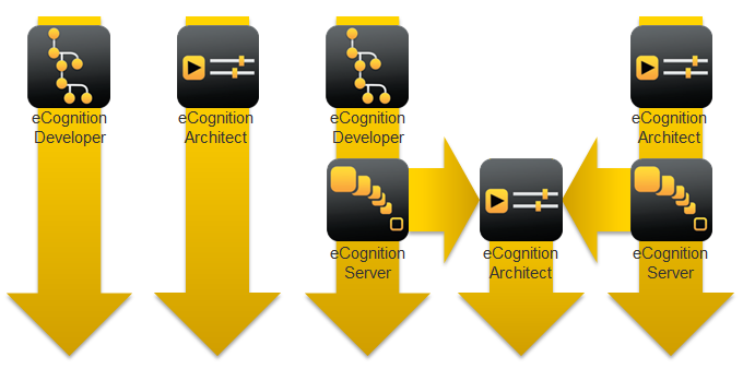
The eCognition Suite offers three different components which can be used stand-alone or in combination to solve even the most challenging fully automated and semi-automated production tasks:
- eCognition Developer is the development environment for object-based image analysis. It is used in geospatial industry to develop Rule Sets or applications for eCognition Architect for the automatic analysis of geospatial data.
- eCognition Architect enables non-technical professionals such as vegetation mapping experts, urban planners or foresters to leverage eCognition technology. Users can easily configure, calibrate and execute analysis applications (Rule Set in combination with a UI) created in eCognition Developer.
- eCognition Server software provides a powerful processing environment for batch and parallel execution of analysis jobs, based on Rule Sets or applications.
eCognition Suite 10.4 Highlights
Region Visualization
Regions have been extensively utilized by eCognition users to focus on specific areas of the complete image. However after creating a region a user was not able to visualize its boundaries. eCongition 10.4 offers region visualization which remove any accessibility issues.
Region Visualization
Full Python Integration: Embedded Python and External API
Following the successful first step in Python Integration in eCognition 10.3, we move forward and offer more capabilities that will enable seamless fusion of eCognition rule set and Python. eCognition 10.4 offers external Python API to allow execution of rulesets (*.dcp) directly in Python. See User Guide > Python Package Documentation . Available only for users with a valid eCognition Server license.
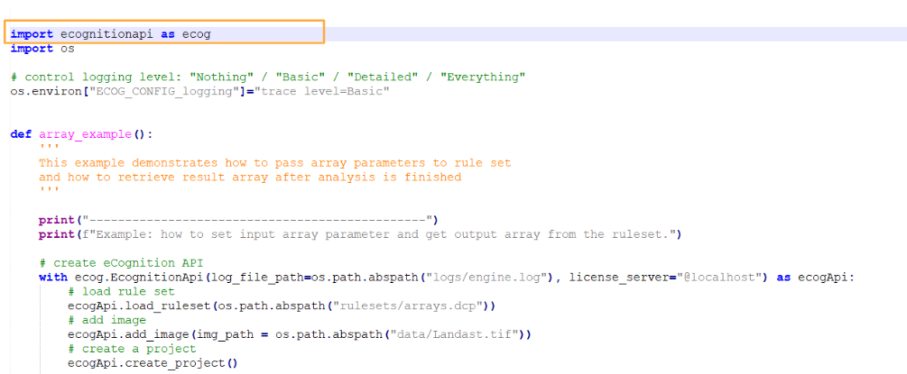
Python Wheel Package - External API
Additionally, for those who have been using our embedded Python, the algorithm 'python script' now supports image objects domain and image object features. For more information please refer to Reference Book > Embedded Python API Reference
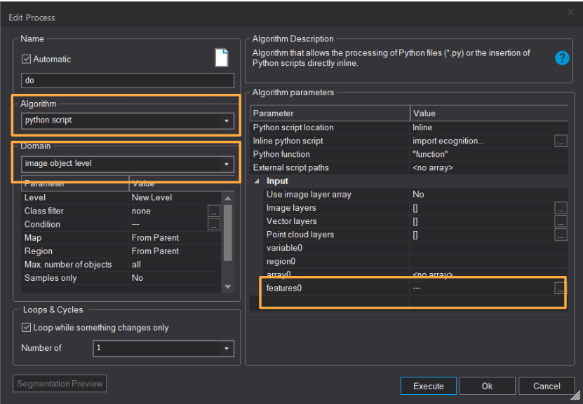
Python script algorithm - Image objects support and image object features support
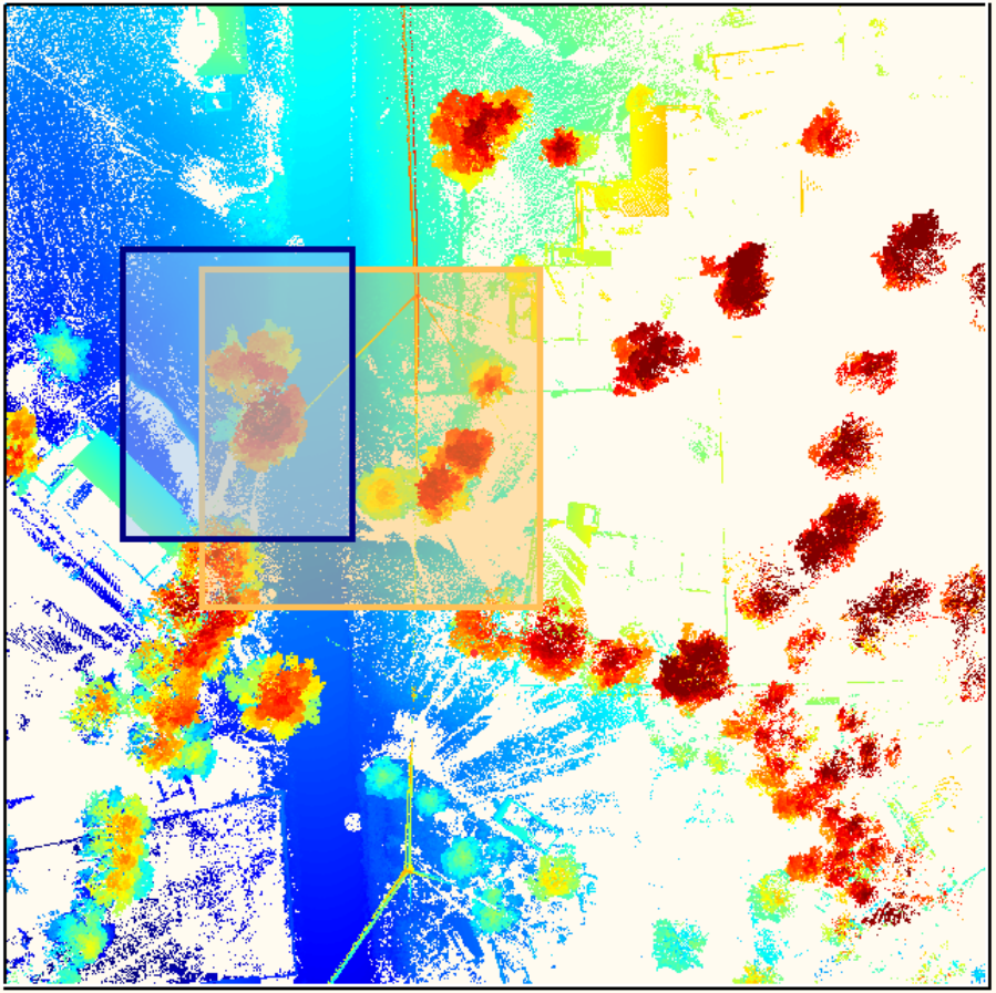
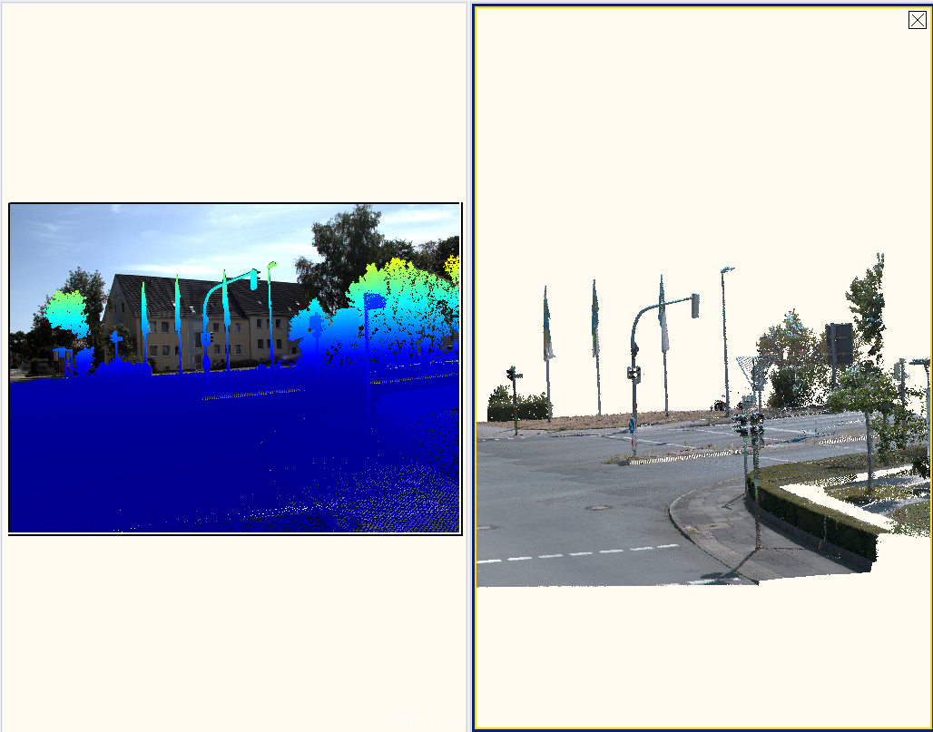
Mobile Mapping Data Support - Camera View
With the rise of mobile mapping in geospatial world, eCognition is equipped with the tools for convenient visualization and processing of complex data sets that comprise of images and point clouds. For more information on how to use this new functionality please refer to Working with Mobile Mapping Data.
Mobile Mapping Data Support
